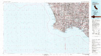
1981 Map of Long Beach
USGS Topo · Published 1981About this map
Los Angeles Harbor and the adjacent industrial and residential sprawl of the South Bay define this early 1980s landscape. The map captures a massive urban corridor from Culver City south to the Palos Verdes Estates, featuring significant maritime and aviation infrastructure including the Los Angeles International Airport and the permanently moored Queen Mary in Long Beach. Military footprints are prominent at the Seal Beach Naval Weapons Sta and the Los Alamitos Armed Forces Reserve Ctr. Along the coast, the topography transitions from the low-lying Ballona Creek wetlands and Marina Del Rey to the dramatic coastal bluffs of Portuguese Bend and Point Fermin. This survey reflects the mature development of the Los Angeles basin, illustrating the dense grid of residential areas like Gardena and Torrance against the backdrop of the San Pedro Bay.
Find a feature on this map
106 named features on this map. Tap any name to fly to it.
Don’t see what you’re looking for? This feature index may not catch every label — zoom into the map to look around manually.
Map Details
Editions of this 1981 Long Beach Map
3 editions found
Other maps of this area

1894 · Los Angeles
USGS Topo · 1:62,500

1894 · Pomona
USGS Topo · 1:62,500

1896 · Santa Ana
USGS Topo · 1:62,500

1896 · Pasadena
USGS Topo · 1:62,500

1896 · Anaheim
USGS Topo · 1:62,500

1896 · Redondo
USGS Topo · 1:62,500

1896 · Las Bolsas
USGS Topo · 1:62,500

1896 · Santa Monica
USGS Topo · 1:62,500

1896 · San Pedro
USGS Topo · 1:62,500

1896 · Downey
USGS Topo · 1:62,500