
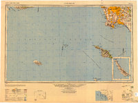
1949 Map of Long Beach
USGS Topo · Published 1949About this map
Santa Monica and the burgeoning South Bay communities define the coastal landscape of this late-1940s survey. The map details the dense urban expansion across the Los Angeles basin, reaching toward Torrance and South Gate during a period of massive post-war growth. Inland, established centers like Whittier and Downey appear alongside smaller aviation and industrial hubs such as Hawthorne and El Segundo.
Find a feature on this map
78 named features on this map. Tap any name to fly to it.
Don’t see what you’re looking for? This feature index may not catch every label — zoom into the map to look around manually.
Map Details
Editions of this 1949 Long Beach Map
2 editions found
Other maps of this area

1894 · Los Angeles
USGS Topo · 1:62,500

1894 · Pomona
USGS Topo · 1:62,500

1896 · Santa Ana
USGS Topo · 1:62,500

1896 · Pasadena
USGS Topo · 1:62,500

1896 · Anaheim
USGS Topo · 1:62,500

1896 · Redondo
USGS Topo · 1:62,500

1896 · Las Bolsas
USGS Topo · 1:62,500

1896 · Santa Monica
USGS Topo · 1:62,500

1896 · San Pedro
USGS Topo · 1:62,500

1896 · Downey
USGS Topo · 1:62,500