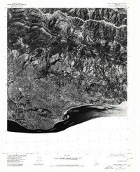
1976 Map of Santa Barbara
USGS Topo · Published 1979About this map
Santa Barbara and the neighboring community of Montecito are captured in high detail in this 1976 orthophotograph, which reveals the dense urban grid pressing against the base of the Santa Ynez Mountains. The sharp contrast between the coastal plain and the steep, shadow-cast ridges leading toward La Cumbre Peak illustrates the geographical constraints that shaped the development of this iconic California coastline. In this era, the transition from urban city blocks to the chaparral-covered hillsides remains abrupt, with the harbor and shoreline defining the southern edge of the built environment. Because this is an orthophotograph produced in cooperation with the Soil Conservation Service, the imagery provides a clear view of the land-use patterns, from the organized blocks of the city center to the winding roads and larger estates on the eastern edge. The map captures the interface of the Pacific Ocean and the Santa Barbara Channel, where the city's marina and beaches serve as the focal point of the waterfront.
Find a feature on this map
5 named features on this map. Tap any name to fly to it.
Don’t see what you’re looking for? This feature index may not catch every label — zoom into the map to look around manually.
Map Details
Editions of this 1976 Santa Barbara Map
This is the sole edition of this map. No revisions or reprints were ever made.
Other maps of this area

1902 · Santa Ynez
USGS Topo · 1:125,000

1905 · Santa Ynez
USGS Topo · 1:125,000

1941 · San Rafael Mtn.
USGS Topo · 1:62,500

1942 · Goleta
USGS Topo · 1:62,500

1942 · San Rafael Mtn.
USGS Topo · 1:62,500

1942 · Little Pine Mountain
USGS Topo · 1:24,000

1943 · San Rafael Mtn.
USGS Topo · 1:62,500

1943 · Hildreth Peak
USGS Topo · 1:24,000

1944 · Santa Barbara
USGS Topo · 1:31,680
1944 · Carpinteria
USGS Topo · 1:31,680
Featured Places
- Santa Barbara, CA
- Montecito, CA
- Mission Canyon, CA
- Vista Del Monte, Santa Barbara
- Las Positas Meadows, Santa Barbara