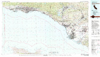
1982 Map of Santa Barbara
USGS Topo · Published 1983About this map
The Santa Ynez Mountains rise abruptly from the Pacific coast, creating a narrow corridor of development from Goleta through Santa Barbara and Carpinteria. By the early 1980s, this landscape shows a complex mix of urban expansion, academic centers like the University of California Santa Barbara, and vast agricultural holdings such as Santa Paula y Saticoy. The Southern Pacific railroad hugs the shoreline, connecting coastal settlements while the interior is dominated by the Los Padres National Forest and the significant reservoir at Lake Casitas.
Find a feature on this map
131 named features on this map. Tap any name to fly to it.
Don’t see what you’re looking for? This feature index may not catch every label — zoom into the map to look around manually.
Map Details
Editions of this 1982 Santa Barbara Map
3 editions found
Other maps of this area

1900 · Triunfo Pass
USGS Topo · 1:62,500

1900 · Piru
USGS Topo · 1:62,500

1902 · Santa Ynez
USGS Topo · 1:125,000

1903 · Santa Paula
USGS Topo · 1:62,500

1903 · Mt. Pinos
USGS Topo · 1:125,000

1903 · Tejon
USGS Topo · 1:125,000

1903 · Camulos
USGS Topo · 1:125,000

1904 · Ventura
USGS Topo · 1:62,500

1904 · Hueneme
USGS Topo · 1:62,500

1905 · Santa Ynez
USGS Topo · 1:125,000