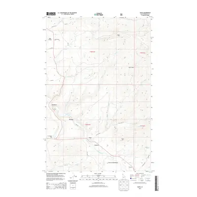
2013 Map of Santa
USGS Topo · Published 2013About this map
The Saint Maries River carves a central path through this section of Benewah County, dictating the placement of early 21st-century settlements and transportation corridors. Small communities such as Santa, Mashburn, and Wayland follow the river valley and the lowlands where Santa Creek and Tyson Creek converge with the main waterway. The presence of Tyson Creek Station and Renfrew highlights the historical importance of this corridor for regional connectivity. In contrast to the settled valleys, the surrounding high ground remains defined by prominent elevations like Pettis Peak, Wilson Mountain, and the long spine of Beaver Ridge. These uplands are crisscrossed by a network of forest roads such as Thorn Creek Road and Renfro Creek Road, serving the logging and recreational interests represented by sites like the Al Vanderpool Picnic Area.
Find a feature on this map
41 named features on this map. Tap any name to fly to it.
Don’t see what you’re looking for? This feature index may not catch every label — zoom into the map to look around manually.
Map Details
Editions of this 2013 Santa Map
This is the sole edition of this map. No revisions or reprints were ever made.
Other maps of this area

1955 · Spokane
USGS Topo · 1:250,000

1957 · St. Maries
USGS Topo · 1:62,500

1957 · Emida
USGS Topo · 1:62,500

1957 · St. Joe
USGS Topo · 1:62,500

1958 · Spokane
USGS Topo · 1:250,000

1961 · Fernwood
USGS Topo · 1:62,500

1981 · St Maries
USGS Topo · 1:100,000
1981 · St Maries
USGS Topo · 1:24,000
1985 · St. Joe Baldy
USGS Topo · 1:24,000
1985 · St. Joe
USGS Topo · 1:24,000