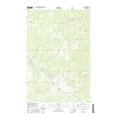
2017 Map of Santa
USGS Topo · Published 2017About this map
The Saint Maries River winds through this Idaho landscape, anchoring several small settlements that define the region's historical development. The community of Santa sits near the confluence of local tributaries, while the former rail stops or timber-related hamlets of Mashburn, Wayland, and Renfrew follow the river valley's natural corridor. The terrain is marked by significant elevations including Pettis Peak and Wilson Mtn, which frame the high country and the grazing lands of Elkhorn Meadows. A network of forest and logging roads such as Davis Creek Rd and Renfro Creek Rd crisscrosses the slopes, illustrating how the geography dictated local travel and industry. To the north, the small settlement of Flat Creek provides a focal point for the headwaters of its namesake stream, Flat Creek, amidst the high points of Beaver Ridge.
Find a feature on this map
48 named features on this map. Tap any name to fly to it.
Don’t see what you’re looking for? This feature index may not catch every label — zoom into the map to look around manually.
Map Details
Editions of this 2017 Santa Map
This is the sole edition of this map. No revisions or reprints were ever made.
Other maps of this area

1955 · Spokane
USGS Topo · 1:250,000

1957 · St. Maries
USGS Topo · 1:62,500

1957 · Emida
USGS Topo · 1:62,500

1957 · St. Joe
USGS Topo · 1:62,500

1958 · Spokane
USGS Topo · 1:250,000

1961 · Fernwood
USGS Topo · 1:62,500

1981 · St Maries
USGS Topo · 1:100,000
1981 · St Maries
USGS Topo · 1:24,000
1985 · St. Joe Baldy
USGS Topo · 1:24,000
1985 · St. Joe
USGS Topo · 1:24,000