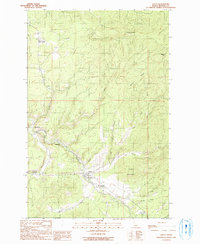
1990 Map of Santa
USGS Topo · Published 1991About this map
The St Maries River valley serves as the central corridor for this North Idaho landscape, where the settlement of Santa sits near the confluence of Santa Creek and the main river. The area's transport and industrial history is visible through a series of small riverside locations including Mashburn, Wayland, and Renfrew, linked by roads that follow the winding riverbank. Heavy timber and steep slopes define the terrain, marked by prominent high points like Pettis Peak and Wilson Mountain. Along the river, specialized infrastructure is noted at the Gauging Station and Sewage Disposal Ponds, while local recreation is centered at the Vanderpool Picnic Area Campground. The map also captures several tributary systems, such as Beaver Creek and Flat Creek, which carve deep drainages into Beaver Ridge as they descend toward the river flats.
Find a feature on this map
32 named features on this map. Tap any name to fly to it.
Don’t see what you’re looking for? This feature index may not catch every label — zoom into the map to look around manually.
Map Details
Editions of this 1990 Santa Map
This is the sole edition of this map. No revisions or reprints were ever made.
Other maps of this area

1955 · Spokane
USGS Topo · 1:250,000

1957 · St. Maries
USGS Topo · 1:62,500

1957 · Emida
USGS Topo · 1:62,500

1957 · St. Joe
USGS Topo · 1:62,500

1958 · Spokane
USGS Topo · 1:250,000

1961 · Fernwood
USGS Topo · 1:62,500

1981 · St Maries
USGS Topo · 1:100,000
1981 · St Maries
USGS Topo · 1:24,000
1985 · St. Joe Baldy
USGS Topo · 1:24,000
1985 · St. Joe
USGS Topo · 1:24,000