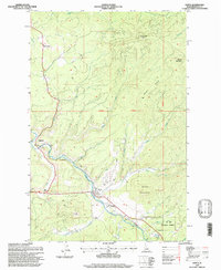
1995 Map of Santa
USGS Topo · Published 1997About this map
The Maries River valley and its surrounding timberlands are the focal point of this late-20th-century topographic record of Benewah County. The settlement of Santa serves as a small hub at the confluence of several mountain drainages, supported by local infrastructure like the nearby Water Towers and the Sewage Disposal Pond. Historically significant sites like Renfrew Cemetery and the river-side community of Mashburn provide anchor points for genealogists and local historians tracking the development of this Idaho panhandle region. The landscape is defined by the heavy timber of the St Joe National Forest, where topography is mapped with precision across Pettis Peak and the high spine of Beaver Ridge. This map reflects the long-standing land management patterns of the Boise Meridian, showing the integration of small riverside settlements within the protected forest boundary during the 1990s.
Find a feature on this map
32 named features on this map. Tap any name to fly to it.
Don’t see what you’re looking for? This feature index may not catch every label — zoom into the map to look around manually.
Map Details
Editions of this 1995 Santa Map
This is the sole edition of this map. No revisions or reprints were ever made.
Other maps of this area

1955 · Spokane
USGS Topo · 1:250,000

1957 · St. Maries
USGS Topo · 1:62,500

1957 · Emida
USGS Topo · 1:62,500

1957 · St. Joe
USGS Topo · 1:62,500

1958 · Spokane
USGS Topo · 1:250,000

1961 · Fernwood
USGS Topo · 1:62,500

1981 · St Maries
USGS Topo · 1:100,000
1981 · St Maries
USGS Topo · 1:24,000
1985 · St. Joe Baldy
USGS Topo · 1:24,000
1985 · St. Joe
USGS Topo · 1:24,000