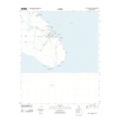
2012 Map of Santa Catalina East
USGS Topo · Published 2012About this map
Avalon serves as the focal point of this coastal survey, where the dense street grid gives way to the steep canyons and ridges of Santa Catalina Island. The map documents a specialized transportation landscape, including the Green Pleasure Pier and aviation facilities such as the Avalon Bay Seaplane Base and Pebbly Beach Seaplane Base. Inland, the terrain is defined by dramatic geography like Grand Canyon and Silver Canyon, while water resources are managed through Wrigley Reservoir and Haypress Reservoir. Notable landmarks like the Wrigley Botanical Gardens and the Catalina Island East End Light anchor the southern and central portions of the sheet. The network of winding routes, such as Stage Rd and Jail and Cemetery Rd, reflects the island's unique infrastructure and historical development outside the main harbor.
Find a feature on this map
51 named features on this map. Tap any name to fly to it.
Don’t see what you’re looking for? This feature index may not catch every label — zoom into the map to look around manually.
Map Details
Editions of this 2012 Santa Catalina East Map
This is the sole edition of this map. No revisions or reprints were ever made.
Other maps of this area

1943 · Santa Catalina North
USGS Topo · 1:24,000

1943 · Santa Catalina East
USGS Topo · 1:24,000

1943 · Santa Catalina South
USGS Topo · 1:24,000

1949 · Long Beach
USGS Topo · 1:250,000
1950 · Santa Catalina South
USGS Topo · 1:24,000
1950 · Santa Catalina East
USGS Topo · 1:24,000
1950 · Santa Catalina North
USGS Topo · 1:24,000

1957 · Long Beach
USGS Topo · 1:250,000

1958 · Long Beach
USGS Topo · 1:250,000

1960 · Long Beach
USGS Topo · 1:250,000