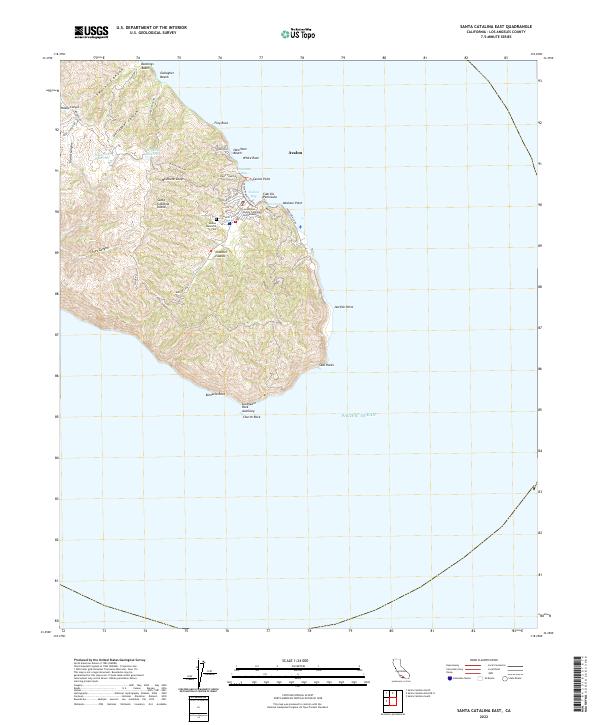
2022 Map of Santa Catalina East
USGS Topo · Published 2022About this map
The coastal town of Avalon serves as the primary gateway to the eastern side of Santa Catalina Island, where the steep terrain of the interior meets the Pacific Ocean. This survey illustrates the dense concentration of infrastructure surrounding Avalon Bay, from the Los Angeles County Catalina Courthouse to the winding paths of the Avalon Waterfront Trl. The map details the transition from the developed waterfront to the rugged canyons of the interior, such as Gallagher Canyon and Silver Canyon. Local water management is evident in the upland basins of Haypress Reservoir and Wrigley Reservoir, essential for sustaining the island community. Along the shoreline, prominent landmarks like Casino Point and the Cabrillo Peninsula define the harbor's character, while the Avalon Memorial Cem provides a point of interest for those tracing the lineage of the island's early residents.
Find a feature on this map
41 named features on this map. Tap any name to fly to it.
Don’t see what you’re looking for? This feature index may not catch every label — zoom into the map to look around manually.
Map Details
Editions of this 2022 Santa Catalina East Map
This is the sole edition of this map. No revisions or reprints were ever made.
Other maps of this area

1943 · Santa Catalina North
USGS Topo · 1:24,000

1943 · Santa Catalina East
USGS Topo · 1:24,000

1943 · Santa Catalina South
USGS Topo · 1:24,000

1949 · Long Beach
USGS Topo · 1:250,000
1950 · Santa Catalina South
USGS Topo · 1:24,000
1950 · Santa Catalina East
USGS Topo · 1:24,000
1950 · Santa Catalina North
USGS Topo · 1:24,000

1957 · Long Beach
USGS Topo · 1:250,000

1958 · Long Beach
USGS Topo · 1:250,000

1960 · Long Beach
USGS Topo · 1:250,000