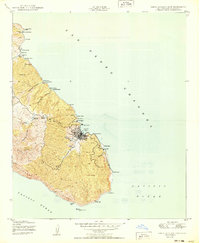
1950 Map of Santa Catalina East
USGS Topo · Published 1950About this map
Avalon serves as the primary gateway to the island's eastern interior, showing a detailed street grid and harbor facilities during the mid-century era. The map illustrates a diverse coastal landscape where recreational sites like the YMCA Camp and Boy Scouts Camp share the shoreline with industrial and maritime landmarks. A small cluster of activity at Toyon and Whites Landing provides context for how the coastline was utilized beyond the main settlement.
Find a feature on this map
45 named features on this map. Tap any name to fly to it.
Don’t see what you’re looking for? This feature index may not catch every label — zoom into the map to look around manually.
Map Details
Editions of this 1950 Santa Catalina East Map
This is the sole edition of this map. No revisions or reprints were ever made.
Other maps of this area

1943 · Santa Catalina North
USGS Topo · 1:24,000

1943 · Santa Catalina East
USGS Topo · 1:24,000

1943 · Santa Catalina South
USGS Topo · 1:24,000

1949 · Long Beach
USGS Topo · 1:250,000
1950 · Santa Catalina South
USGS Topo · 1:24,000
1950 · Santa Catalina North
USGS Topo · 1:24,000

1957 · Long Beach
USGS Topo · 1:250,000

1958 · Long Beach
USGS Topo · 1:250,000

1960 · Long Beach
USGS Topo · 1:250,000
1981 · Santa Catalina Island
USGS Topo · 1:100,000