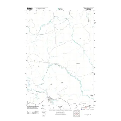
2013 Map of Santa Clara
USGS Topo · Published 2013About this map
Santa Clara serves as the focal point for this section of Franklin County, where the village streets of Red Ave and Center St meet against the backdrop of Little Hurd Hill. The landscape is defined by the winding course of the E Br Saint Regis River and the Saint Regis River, which carve through a terrain marked by numerous peaks like The Pinnacle and Mutton Ridge. To the north, the settlement of Reynoldston sits near the Deer River, connected by a network of rural routes including Reynoldston Rd and Townline Rd. The presence of Trombley Landing and several isolated water bodies such as Long Pond, Black Pond, and Deer Pond suggests a region historically tied to timber and water-based transport. This detailed survey preserves the modern placement of family-named landmarks like Cheney Hill and Mulholland Hill alongside contemporary road classifications.
Find a feature on this map
53 named features on this map. Tap any name to fly to it.
Don’t see what you’re looking for? This feature index may not catch every label — zoom into the map to look around manually.
Map Details
Editions of this 2013 Santa Clara Map
This is the sole edition of this map. No revisions or reprints were ever made.
Other maps of this area

1915 · Malone
USGS Topo · 1:62,500

1915 · Moira
USGS Topo · 1:62,500

1917 · Malone
USGS Topo · 1:62,500

1917 · Moira
USGS Topo · 1:62,500

1919 · Nicholville
USGS Topo · 1:62,500

1921 · Nicholville
USGS Topo · 1:62,500

1921 · Santa Clara
USGS Topo · 1:62,500

1923 · Santa Clara
USGS Topo · 1:62,500

1944 · Moira
USGS Topo · 1:62,500

1948 · Ogdensburg
USGS Topo · 1:250,000