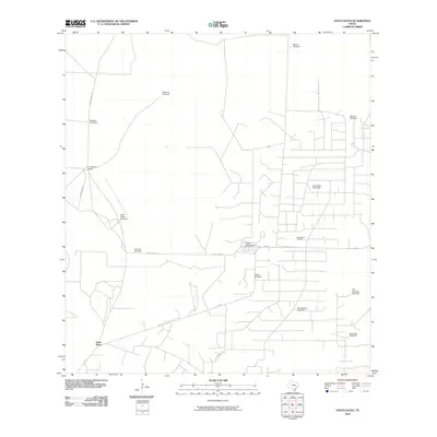
2010 Map of Santa Elena
USGS Topo · Published 2010About this map
Santa Elena anchors this South Texas landscape, where the distribution of water and oil defines the regional economy. The map reveals a high concentration of livestock infrastructure, characterized by numerous named wind-powered pumps such as Casa Blanca Windmill, Mirasol Windmill, and Santa Teresa Windmill. These landmarks serve as vital navigational and resource points across a territory carved by ranching roads like Bazon Ranch Rd and Kelsy Bass Rd. The intersection of traditional agriculture and industrial development is evident in the presence of the Kelsey Bass Oil Field, which sits adjacent to the residential Kelsey Bass Camp. This 2010 survey provides a clear view of the ranching legacy in Starr County, showing how named sites like La Particion Ranch maintain the area's historical identity in an era of energy extraction.
Find a feature on this map
19 named features on this map. Tap any name to fly to it.
Don’t see what you’re looking for? This feature index may not catch every label — zoom into the map to look around manually.
Map Details
Editions of this 2010 Santa Elena Map
This is the sole edition of this map. No revisions or reprints were ever made.
Other maps of this area

1938 · Agua Nueva
USGS Topo · 1:62,500

1938 · Sal Colorada
USGS Topo · 1:62,500

1939 · La Reforma
USGS Topo · 1:62,500

1939 · Encantada
USGS Topo · 1:62,500

1949 · Mc Allen
USGS Topo · 1:250,000

1954 · McAllen
USGS Topo · 1:250,000

1957 · Mc Allen
USGS Topo · 1:250,000

1962 · McAllen
USGS Topo · 1:250,000
1972 · Santa Elena SE
USGS Topo · 1:24,000
1972 · Tacubaya
USGS Topo · 1:24,000