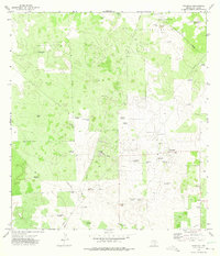
1972 Map of Tacubaya
USGS Topo · Published 1975About this map
Tacubaya and the surrounding ranchlands of Brooks County reveal a landscape defined by the extraction of water and oil in the early 1970s. The territory is dominated by the Alta Mesa Oil Field and the Scott and Hopper Oil Field, where a network of pipelines, pumping stations, and drill holes overlays the traditional grazing land. This era shows the transition from isolated ranch life to industrial utility, with clusters of activity at Alta Mesa Camp and the nearby Alto Colorado Ranch, which features its own Landing Strip.
Find a feature on this map
38 named features on this map. Tap any name to fly to it.
Don’t see what you’re looking for? This feature index may not catch every label — zoom into the map to look around manually.
Map Details
Editions of this 1972 Tacubaya Map
2 editions found
Other maps of this area

1921 · Falfurrias
USGS Topo · 1:125,000

1939 · Encantada
USGS Topo · 1:62,500

1949 · Mc Allen
USGS Topo · 1:250,000

1954 · McAllen
USGS Topo · 1:250,000

1956 · Laredo
USGS Topo · 1:250,000

1957 · Mc Allen
USGS Topo · 1:250,000

1962 · McAllen
USGS Topo · 1:250,000

1963 · Cage Ranch
USGS Topo · 1:24,000
1963 · Encino
USGS Topo · 1:24,000
1963 · Hartland
USGS Topo · 1:24,000