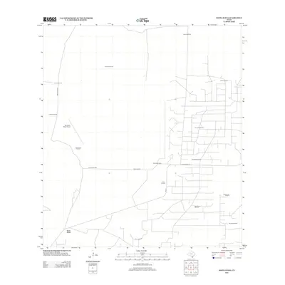
2012 Map of Santa Elena
USGS Topo · Published 2012About this map
Santa Elena anchors this South Texas landscape, where the traditional ranching economy and the modern energy industry meet. The map reveals a lattice of ranch roads and specialized sites, most notably the Kelsey Bass Oil Field and the nearby Kelsey Bass Camp, which indicate the significance of petroleum extraction to this region of Starr County. Named ranching landmarks like La Particion Ranch are interspersed with a network of critical water infrastructure, including Blanco Windmill, Mirasol Windmill, and Old Encinitas Windmill. This infrastructure reflects the necessity of groundwater management in a terrain defined by private holdings and cattle operations. Local transportation is facilitated by thoroughfares such as Bazon Ranch Rd and Ranch Road 755, while the San Rafael Ranch Airport provides an essential aerial link for this expansive ranching territory.
Find a feature on this map
21 named features on this map. Tap any name to fly to it.
Don’t see what you’re looking for? This feature index may not catch every label — zoom into the map to look around manually.
Map Details
Editions of this 2012 Santa Elena Map
This is the sole edition of this map. No revisions or reprints were ever made.
Other maps of this area

1938 · Agua Nueva
USGS Topo · 1:62,500

1938 · Sal Colorada
USGS Topo · 1:62,500

1939 · La Reforma
USGS Topo · 1:62,500

1939 · Encantada
USGS Topo · 1:62,500

1949 · Mc Allen
USGS Topo · 1:250,000

1954 · McAllen
USGS Topo · 1:250,000

1957 · Mc Allen
USGS Topo · 1:250,000

1962 · McAllen
USGS Topo · 1:250,000
1972 · Santa Elena SE
USGS Topo · 1:24,000
1972 · Tacubaya
USGS Topo · 1:24,000