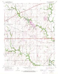
1955 Map of Santa Fe Lake
USGS Topo · Published 1971About this map
Butler County State Park serves as a central landmark for this region of Kansas, framing the waters of Santa Fe Lake as they are fed by Dry Creek. The landscape transition from the mid-1950s to 1970 is evident through the inclusion of the Kansas Turnpike and its associated toll road infrastructure cutting across the northern sections. This era shows a community in flux, where traditional rural markers like the Indianola Sch and small cemeteries such as Indianola Cem and Golden Cem coexist with mid-century industrial growth. Petroleum extraction is documented through several Oil Wells and a dedicated Oil Tank near the southern boundary. Transportation remains a dominant theme, with the Augusta Municipal Airport and the heavy rail corridors of the St Louis San Francisco and Atchison Topeka and Santa Fe lines shaping the development of townships like Augusta and Bruno.
Find a feature on this map
32 named features on this map. Tap any name to fly to it.
Don’t see what you’re looking for? This feature index may not catch every label — zoom into the map to look around manually.
Map Details
Editions of this 1955 Santa Fe Lake Map
3 editions found
Other maps of this area

1888 · Eldorado
USGS Topo · 1:125,000

1889 · Wichita
USGS Topo · 1:125,000

1894 · Wichita
USGS Topo · 1:125,000

1945 · Andover
USGS Topo · 1:31,680

1955 · Santa Fe Lake
USGS Topo · 1:24,000

1955 · Benton
USGS Topo · 1:24,000

1955 · Greenwich
USGS Topo · 1:24,000

1955 · Rose Hill
USGS Topo · 1:24,000

1955 · Douglass
USGS Topo · 1:24,000

1955 · Wichita
USGS Topo · 1:250,000