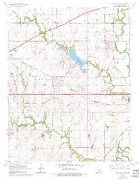
1955 Map of Santa Fe Lake
USGS Topo · Published 1983About this map
Santa Fe Lake serves as a central landmark in this Butler County landscape, situated where the Kansas Turnpike and Burlington Northern railroad intersect the rural townships. The map documents a transition from traditional agriculture to modern infrastructure, evidenced by the presence of the Augusta Municipal Airport alongside established rural institutions like Indianola Sch and Lily Lake Sch. Local families and genealogists can identify several historic burial sites, including Indianola Cem, Fairview Cem, and Golden Cem, which anchor the settlement history of Benton, Towanda, and Augusta.
Find a feature on this map
33 named features on this map. Tap any name to fly to it.
Don’t see what you’re looking for? This feature index may not catch every label — zoom into the map to look around manually.
Map Details
Editions of this 1955 Santa Fe Lake Map
3 editions found
Other maps of this area

1888 · Eldorado
USGS Topo · 1:125,000

1889 · Wichita
USGS Topo · 1:125,000

1894 · Wichita
USGS Topo · 1:125,000

1945 · Andover
USGS Topo · 1:31,680

1955 · Santa Fe Lake
USGS Topo · 1:24,000

1955 · Benton
USGS Topo · 1:24,000

1955 · Greenwich
USGS Topo · 1:24,000

1955 · Rose Hill
USGS Topo · 1:24,000

1955 · Douglass
USGS Topo · 1:24,000

1955 · Wichita
USGS Topo · 1:250,000