
1945 Map of Andover
USGS Topo · Published 1945About this map
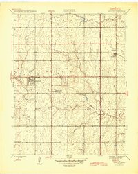
The Sedgwick Co Butler Co boundary line divides this prairie landscape during the mid-1940s, anchored by the community of Andover. The era's educational network is remarkably dense, featuring specialized local sites like Mammoth Cave Sch and Vernon Sch, alongside the Andover Sch. Small suburban developments such as Forest Hills and Linwood Acres suggest the early outward growth of nearby urban centers into the surrounding townships of Minneha and Bruno.
Find a feature on this map
31 named features on this map. Tap any name to fly to it.
Don’t see what you’re looking for? This feature index may not catch every label — zoom into the map to look around manually.
Map Details
Editions of this 1945 Andover Map
2 editions found
Other maps of this area

1889 · Wichita
USGS Topo · 1:125,000

1894 · Wichita
USGS Topo · 1:125,000

1941 · Valley Center
USGS Topo · 1:31,680

1942 · Valley Center
USGS Topo · 1:31,680

1943 · Wichita East
USGS Topo · 1:31,680

1943 · Derby
USGS Topo · 1:31,680

1955 · Santa Fe Lake
USGS Topo · 1:24,000

1955 · Benton
USGS Topo · 1:24,000

1955 · Greenwich
USGS Topo · 1:24,000

1955 · Rose Hill
USGS Topo · 1:24,000