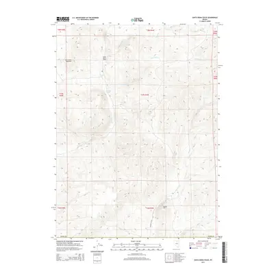
2014 Map of Santa Renia Fields
USGS Topo · Published 2014About this map
Santa Renia Fields occupies a high-elevation basin in Elko County, defined by the northern reaches of the Santa Renia Mountains. This 2014 survey documents a rugged landscape where ephemeral drainages like Antelope Cr and Antelope Draw carve through the terrain. The presence of Boulder Flat Rd indicates the primary corridor for movement through this area of northeastern Nevada, connecting the remote flats with the surrounding peaks. To the east and south, the map follows the winding paths of Little Coyote Cr and Boulder Cr, which descend toward the lower basins. Significant landmarks such as Round Mtn provide vertical relief in an area characterized by its wide-open rangeland and complex drainage networks including Bell Cr and Squaw Cr.
Find a feature on this map
11 named features on this map. Tap any name to fly to it.
Don’t see what you’re looking for? This feature index may not catch every label — zoom into the map to look around manually.
Map Details
Editions of this 2014 Santa Renia Fields Map
This is the sole edition of this map. No revisions or reprints were ever made.
Other maps of this area

1955 · McDermitt
USGS Topo · 1:250,000

1955 · Winnemucca
USGS Topo · 1:250,000

1958 · Winnemucca
USGS Topo · 1:250,000

1959 · McDermitt
USGS Topo · 1:250,000

1962 · Winnemucca
USGS Topo · 1:250,000

1965 · Willow Creek Reservoir
USGS Topo · 1:24,000

1965 · Sheep Creek Range NE
USGS Topo · 1:24,000
1965 · Willow Creek Reservoir SE
USGS Topo · 1:24,000

1968 · Rodeo Creek NE
USGS Topo · 1:24,000

1968 · Rodeo Creek NW
USGS Topo · 1:24,000