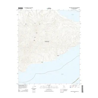
2015 Map of Santa Rosa Island South
USGS Topo · Published 2015About this map
Channel Islands National Park encompasses the southern portion of Santa Rosa Island in this contemporary topographic survey, showcasing a landscape defined by dramatic drainage systems. Steep-walled ravines like Wreck Canyon and Jolla Vieja Canyon cut through the high terrain, draining southward toward the Pacific Ocean. This coastal segment of Santa Barbara County is largely undeveloped, with names like Cañada Soledad and San Augustin Canyon marking the island's primary geographic features. The map illustrates the island's rugged interior ridges separated by canyons such as Dry Canyon and Cow Canyon, which descend toward the southern and western coastlines. The lack of roads or structures highlights the protected, wilderness character of the island as it appeared in the early 21st century.
Find a feature on this map
11 named features on this map. Tap any name to fly to it.
Don’t see what you’re looking for? This feature index may not catch every label — zoom into the map to look around manually.
Map Details
Editions of this 2015 Santa Rosa Island South Map
This is the sole edition of this map. No revisions or reprints were ever made.
Other maps of this area
1943 · Santa Rosa Island East
USGS Topo · 1:24,000
1943 · Santa Rosa Island South
USGS Topo · 1:24,000
1943 · Santa Rosa Island North
USGS Topo · 1:24,000

1948 · Santa Maria
USGS Topo · 1:250,000

1949 · Los Angeles
USGS Topo · 1:250,000

1949 · Long Beach
USGS Topo · 1:250,000

1955 · Los Angeles
USGS Topo · 1:250,000

1956 · Santa Maria
USGS Topo · 1:250,000

1957 · Long Beach
USGS Topo · 1:250,000

1957 · Santa Maria
USGS Topo · 1:250,000