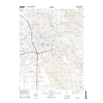
2015 Map of Santa Rosa
USGS Topo · Published 2015About this map
Santa Rosa serves as the central hub of this 2015 survey, revealing a dense concentration of historical burial grounds including the Santa Rosa Rural Cemetery, Independent Order of Oddfellows Cemetery, and the Fulkerson Cemetery. The map captures the suburban expansion of communities like Montgomery Village, Roseland, and Bellevue, showing how the modern city footprint integrates with the older settlement patterns of Rincon Valley and Monroe. The landscape is defined by the waterways of Santa Rosa Creek and Matanzas Creek, which flow through the urban core toward the Santa Rosa Creek Reservoir. To the southeast, the terrain rises sharply toward Taylor Mountain and Cooks Peak, marking a clear boundary between the developed valley floor and the open spaces of Bennett Valley. Educational and commercial institutions like the Santa Rosa Junior College and Empire College School of Business appear alongside the vital transport corridor of Us Highway 101.
Find a feature on this map
51 named features on this map. Tap any name to fly to it.
Don’t see what you’re looking for? This feature index may not catch every label — zoom into the map to look around manually.
Map Details
Editions of this 2015 Santa Rosa Map
This is the sole edition of this map. No revisions or reprints were ever made.
Other maps of this area

1916 · Santa Rosa
USGS Topo · 1:62,500

1920 · Healdsburg
USGS Topo · 1:62,500

1927 · Calistoga
USGS Topo · 1:62,500

1933 · Healdsburg
USGS Topo · 1:48,000

1935 · Sebastopol
USGS Topo · 1:48,000

1940 · Healdsburg
USGS Topo · 1:62,500

1942 · Sebastopol
USGS Topo · 1:62,500

1943 · Calistoga
USGS Topo · 1:62,500

1944 · Santa Rosa
USGS Topo · 1:62,500

1945 · Calistoga
USGS Topo · 1:62,500