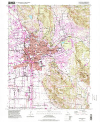
1994 Map of Santa Rosa
USGS Topo · Published 1999About this map
Santa Rosa serves as the focal point of this mid-1990s landscape, illustrating a period of significant suburban expansion between the hills of Annadel State Park and the lowlands of Bellevue. The map documents the city's civic and cultural heart, featuring the Luther Burbank Gardens and the Sonoma County Fairgrounds. Transportation patterns are defined by the Northwestern Pacific railroad corridor and the branching road network of Montgomery Village and Rincon Valley.
Find a feature on this map
91 named features on this map. Tap any name to fly to it.
Don’t see what you’re looking for? This feature index may not catch every label — zoom into the map to look around manually.
Map Details
Editions of this 1994 Santa Rosa Map
This is the sole edition of this map. No revisions or reprints were ever made.
Other maps of this area

1916 · Santa Rosa
USGS Topo · 1:62,500

1920 · Healdsburg
USGS Topo · 1:62,500

1927 · Calistoga
USGS Topo · 1:62,500

1933 · Healdsburg
USGS Topo · 1:48,000

1935 · Sebastopol
USGS Topo · 1:48,000

1940 · Healdsburg
USGS Topo · 1:62,500

1942 · Sebastopol
USGS Topo · 1:62,500

1943 · Calistoga
USGS Topo · 1:62,500

1944 · Santa Rosa
USGS Topo · 1:62,500

1945 · Calistoga
USGS Topo · 1:62,500
Featured Places
- Santa Rosa, CA
- Bellevue, Santa Rosa
- Melita, Santa Rosa
- Larkfield-Wikiup, CA
- South Santa Rosa, Santa Rosa