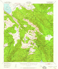
1939 Map of Santa Ysabel
USGS Topo · Published 1959About this map
The Santa Ysabel Indian Reservation and Mesa Grande Indian Reservation anchor this 1939 survey, revealing a landscape defined by ranching, mining, and Indigenous heritage. In the northern reaches, Lake Henshaw dominates the valley below Valle de San Jose, while further south, the settlement of Julian serves as a hub for the surrounding mountains. Mining activity is concentrated along the steep eastern slopes, where the Banner Queen Mine and Golden Chariot Mine mark the mineral-rich veins of the Oriflamme and Chariot canyons.
Find a feature on this map
70 named features on this map. Tap any name to fly to it.
Don’t see what you’re looking for? This feature index may not catch every label — zoom into the map to look around manually.
Map Details
Editions of this 1939 Santa Ysabel Map
2 editions found

Other maps of this area

1893 · El Cajon
USGS Topo · 1:62,500

1901 · Elcajon
USGS Topo · 1:62,500

1903 · Cuyamaca
USGS Topo · 1:125,000

1903 · Elcajon
USGS Topo · 1:62,500

1903 · Ramona
USGS Topo · 1:125,000

1904 · Indio
USGS Topo · 1:125,000

1904 · Southern California Sheet No. 2
USGS Topo · 1:250,000

1931 · Vallecito
USGS Topo · 1:125,000

1931 · Carrizo
USGS Topo · 1:125,000

1939 · El Cajon
USGS Topo · 1:62,500