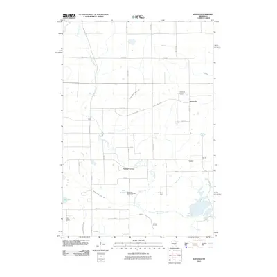
2010 Map of Santiago
USGS Topo · Published 2010About this map
The Saint Francis River meanders through the heart of Sherburne County, defining the agricultural and hydrographic character of this central Minnesota landscape. Near its banks, the settlement of Santiago serves as a local hub, anchored by the Santiago Post Office and surrounded by a network of rural roads such as County Hwy 48 and Ronneby Rd SE. The map reveals a deeply rooted community structure, evidenced by numerous historical burying grounds including South Santiago Cemetery, Oak Hill Cemetery, and Saint Francis Cemetery.
Find a feature on this map
53 named features on this map. Tap any name to fly to it.
Don’t see what you’re looking for? This feature index may not catch every label — zoom into the map to look around manually.
Map Details
Editions of this 2010 Santiago Map
This is the sole edition of this map. No revisions or reprints were ever made.
Other maps of this area

1953 · Stillwater
USGS Topo · 1:250,000

1955 · Stillwater
USGS Topo · 1:250,000

1958 · Stillwater
USGS Topo · 1:250,000

1961 · Clear Lake
USGS Topo · 1:24,000

1961 · Orrock
USGS Topo · 1:24,000

1961 · Becker
USGS Topo · 1:24,000

1961 · Monticello
USGS Topo · 1:62,500

1961 · Elk River
USGS Topo · 1:62,500

1965 · Stillwater
USGS Topo · 1:250,000
1968 · Foley
USGS Topo · 1:24,000