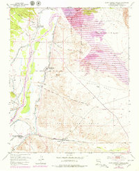
1953 Map of Santo Domingo Pueblo
USGS Topo · Published 1979About this map
The Rio Grande valley serves as the central artery for this mid-century New Mexico landscape, dominated by the long-established sovereign lands of the Santo Domingo Pueblo and Cochiti Pueblo. The 1950s survey captures a transition in water management and land use, evidenced by the emerging Cochiti Lake and the complex irrigation network of the Santo Domingo Ditch and the Santo Domingo Drain. These systems supported agricultural life in the valley, connecting settlements like Peña Blanca and Sile. To the south, the railroad town of Domingo sits along the Atchison Topeka and Santa Fe, marking a vital transportation link for the region. The map also delineates historical land boundaries such as the La Majada Grant and Caja del Rio Grant, reflecting the intersection of Spanish land grants and Indigenous territories that define this portion of Sandoval County.
Find a feature on this map
32 named features on this map. Tap any name to fly to it.
Don’t see what you’re looking for? This feature index may not catch every label — zoom into the map to look around manually.
Map Details
Editions of this 1953 Santo Domingo Pueblo Map
5 editions found
Other maps of this area

1892 · San Pedro
USGS Topo · 1:125,000

1892 · Santa Clara
USGS Topo · 1:125,000

1952 · Montoso Peak
USGS Topo · 1:24,000

1953 · Cochiti Dam
USGS Topo · 1:24,000

1953 · Santo Domingo Pueblo
USGS Topo · 1:24,000

1953 · Tetilla Peak
USGS Topo · 1:24,000

1953 · Santo Domingo Pueblo SW
USGS Topo · 1:24,000

1953 · Canada
USGS Topo · 1:24,000

1953 · Agua Fria
USGS Topo · 1:62,500

1953 · Santo Domingo Pueblo
USGS Topo · 1:62,500