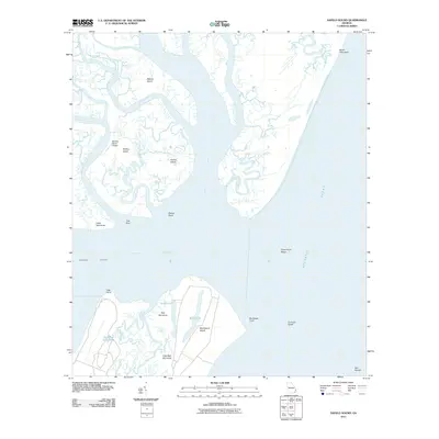
2011 Map of Sapelo Sound
USGS Topo · Published 2011About this map
Blackbeard Island and the intricate tidal marshes of the Georgia coast define this landscape, where the Intracostal Waterway cuts through Sapelo Sound. The map reveals a complex network of estuarine rivers, including the Wahoo River, Swain River, and South Newport River, which separate numerous hammocks and islands. Local navigation and land use are evident through features like the Barbour Island Airport on Barbour Island and managed water bodies such as Reynolds Duck Pond. The terrain is marked by shifting shoals like Experiment Shoal and Concord Shoal, illustrating the dynamic nature of the Atlantic interface. Genealogists and local historians can trace the naming of various landforms, from Oldnor Island to Cedar Hammock, which reflect the long-standing maritime and agricultural heritage of the Sea Islands region.
Find a feature on this map
30 named features on this map. Tap any name to fly to it.
Don’t see what you’re looking for? This feature index may not catch every label — zoom into the map to look around manually.
Map Details
Editions of this 2011 Sapelo Sound Map
This is the sole edition of this map. No revisions or reprints were ever made.
Other maps of this area

1920 · Sapelo River
USGS Topo · 1:62,500

1920 · Cabretta Island
USGS Topo · 1:62,500

1921 · Darien
USGS Topo · 1:62,500

1928 · St Catherines Island
USGS Topo · 1:62,500

1943 · St Catherines Island
USGS Topo · 1:62,500

1943 · Sapelo River
USGS Topo · 1:62,500

1944 · Cabretta Island
USGS Topo · 1:62,500

1945 · St. Catherine's Island
USGS Topo · 1:62,500

1945 · Sapelo River
USGS Topo · 1:62,500

1946 · Brunswick
USGS Topo · 1:250,000