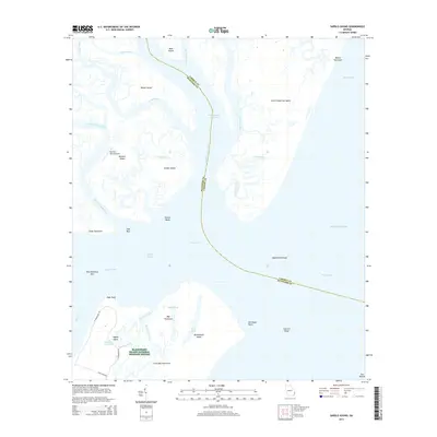
2014 Map of Sapelo Sound
USGS Topo · Published 2014About this map
Blackbeard Island National Wildlife Refuge dominates the southern coastal reaches of this Liberty County survey, preserving a complex of barrier islands and tidal marshes. The intricate network of waterways including the Sapelo River, Swain River, and the Intracoastal Waterway defines the landscape, separating major landmasses like Saint Catherines Island and Blackbeard Island from the mainland. Historically significant features such as the Barbour Island Airport on Barbour Island and the private network of roads including E Perimeter Rd and W Perimeter Rd on Sapelo Island provide insight into the unique land use and conservation efforts in the Sea Islands chain. Researchers will find a detailed coastal topography, from the Experiment Shoal in Sapelo Sound to the interior wetlands of Flag Pond and North Pond.
Find a feature on this map
46 named features on this map. Tap any name to fly to it.
Don’t see what you’re looking for? This feature index may not catch every label — zoom into the map to look around manually.
Map Details
Editions of this 2014 Sapelo Sound Map
This is the sole edition of this map. No revisions or reprints were ever made.
Other maps of this area

1920 · Sapelo River
USGS Topo · 1:62,500

1920 · Cabretta Island
USGS Topo · 1:62,500

1921 · Darien
USGS Topo · 1:62,500

1928 · St Catherines Island
USGS Topo · 1:62,500

1943 · St Catherines Island
USGS Topo · 1:62,500

1943 · Sapelo River
USGS Topo · 1:62,500

1944 · Cabretta Island
USGS Topo · 1:62,500

1945 · St. Catherine's Island
USGS Topo · 1:62,500

1945 · Sapelo River
USGS Topo · 1:62,500

1946 · Brunswick
USGS Topo · 1:250,000