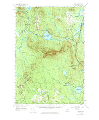
1957 Map of Saponac
USGS Topo · Published 1977About this map
Passadumkeag Mountain and Grand Falls Mountain dominate the central topography of this mid-century Penobscot County landscape. The Passadumkeag River snakes through the lowlands, marked by distinct river features such as White Horse Rips, Pond Rips, and the prominent Grand Falls near the settlement of Saponac. This era reveals a transition from traditional river-and-forest economies toward modern resource management, evidenced by the presence of a Gaging Sta and a Lookout Tower atop the peaks.
Find a feature on this map
92 named features on this map. Tap any name to fly to it.
Don’t see what you’re looking for? This feature index may not catch every label — zoom into the map to look around manually.
Map Details
Editions of this 1957 Saponac Map
4 editions found

Other maps of this area

1902 · Orono
USGS Topo · 1:62,500

1917 · Passadumkeag
USGS Topo · 1:62,500

1920 · Winn
USGS Topo · 1:62,500

1929 · Great Pond
USGS Topo · 1:48,000

1929 · Lead Mountain
USGS Topo · 1:48,000

1931 · Springfield
USGS Topo · 1:48,000

1931 · Saponac
USGS Topo · 1:48,000

1932 · Nicatous Lake
USGS Topo · 1:48,000

1932 · Lead Mountain
USGS Topo · 1:62,500

1932 · Great Pond
USGS Topo · 1:62,500