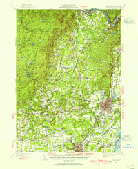
1947 Map of Saratoga
USGS Topo · Published 1955About this map
Ballston Spa and the surrounding Saratoga County landscape appear here in mid-century detail, centered on the complex social and industrial geography of the region. The map captures the specialized layout of the Saratoga Reservation and the famous Saratoga Track, illustrating the area's long-standing identity as a destination for health and sport. Beyond the resort center, the terrain is defined by the Kayaderosseras and Hudson River drainage, where small industrial nodes like Rock City Falls and Factory Village were established. The presence of the County Home and Skidmore College reflects the institutional development of the era, while the Delaware And Hudson railroad provides the backbone for the local economy. In the more secluded western reaches, landmarks such as Lake Desolation and various camps suggest a shift toward recreational forestry and leisure in the foothills of the Adirondack Mountains.
Find a feature on this map
143 named features on this map. Tap any name to fly to it.
Don’t see what you’re looking for? This feature index may not catch every label — zoom into the map to look around manually.
Map Details
Editions of this 1947 Saratoga Map
3 editions found
Other maps of this area

1893 · Cohoes
USGS Topo · 1:62,500

1893 · Schenectady
USGS Topo · 1:62,500

1895 · Cohoes
USGS Topo · 1:62,500

1895 · Schenectady
USGS Topo · 1:62,500

1895 · Amsterdam
USGS Topo · 1:62,500

1895 · Glens Falls
USGS Topo · 1:62,500

1897 · Glens Falls
USGS Topo · 1:62,500

1898 · Schenectady
USGS Topo · 1:62,500

1898 · Cohoes
USGS Topo · 1:62,500

1899 · Broadalbin
USGS Topo · 1:62,500