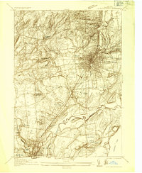
1934 Map of Saratoga Springs
USGS Topo · Published 1934About this map
Saratoga Springs and Ballston Spa serve as the primary hubs in this 1934 survey, connected by the Delaware and Hudson railroad and several state highways. The landscape is a detailed mix of recreational spaces and institutional land, including the Saratoga Golf Club, Saratoga State Park, and the unique Petrified Gardens to the west. On the outskirts of the municipalities, specialized agricultural and research sites like the US Fur Animal Experiment Station and the State Forest Nursery indicate the region's diverse economic activities during the interwar years.
Find a feature on this map
49 named features on this map. Tap any name to fly to it.
Don’t see what you’re looking for? This feature index may not catch every label — zoom into the map to look around manually.
Map Details
Editions of this 1934 Saratoga Springs Map
This is the sole edition of this map. No revisions or reprints were ever made.
Other maps of this area

1893 · Cohoes
USGS Topo · 1:62,500

1893 · Schenectady
USGS Topo · 1:62,500

1895 · Cohoes
USGS Topo · 1:62,500

1895 · Schenectady
USGS Topo · 1:62,500

1898 · Schenectady
USGS Topo · 1:62,500

1898 · Cohoes
USGS Topo · 1:62,500

1900 · Schuylerville
USGS Topo · 1:62,500

1902 · Saratoga
USGS Topo · 1:62,500
1929 · Cohoes
USGS Topo · 1:62,500

1930 · Schenectady
USGS Topo · 1:62,500