
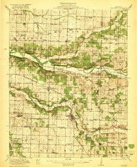
1921 Map of Sarcoxie
USGS Topo · Published 1921About this map
The Spring River and its numerous tributaries, including White Oak Creek and Center Creek, define the southwest Missouri landscape as it appeared in the early twentieth century. This survey reflects a deeply established rural society organized around an dense network of country schools and churches. Sarcoxie serves as the primary hub, where the St Louis San Francisco railroad facilitated local industry. Evidence of the region’s milling and mining heritage is preserved in labels for Forest Mills, Hoosick Mill, and the Red Fox Mine near Reeds. Genealogists can trace family footprints through numerous named landmarks such as Motley Cemetery and the many one-room schoolhouses like Charter Oak School and Sunflower School that once dotted the townships of Madison, Sarcoxie, and Mt Pleasant.
Find a feature on this map
91 named features on this map. Tap any name to fly to it.
Don’t see what you’re looking for? This feature index may not catch every label — zoom into the map to look around manually.
Map Details
Editions of this 1921 Sarcoxie Map
2 editions found
Other maps of this area

1886 · Greenfield
USGS Topo · 1:125,000

1886 · Carthage
USGS Topo · 1:125,000

1888 · Greenfield
USGS Topo · 1:125,000

1894 · Carthage
USGS Topo · 1:125,000

1916 · Neosho
USGS Topo · 1:62,500

1921 · Stotts City
USGS Topo · 1:62,500

1943 · Ritchey
USGS Topo · 1:62,500

1943 · Monett
USGS Topo · 1:62,500

1945 · Harrison
USGS Topo · 1:250,000

1947 · Joplin
USGS Topo · 1:250,000