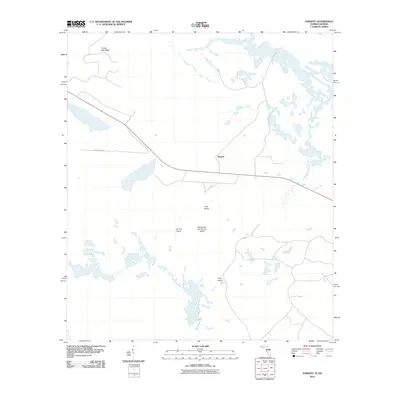
2011 Map of Sargent
USGS Topo · Published 2011About this map
Sargent sits at the heart of this wetland-rich landscape on the Florida-Georgia border, where low-lying terrain gives rise to several named hummocks and islands. The northern portion is defined by Turkey Nest Head and a complex network of waterways, while the central and southern reaches are marked by distinctive landmarks such as Long Island and the curiously named Devils Cup and Saucer Island. These features suggest a local geography where dry land is a premium, likely influencing historical land use and early cattle ranging, as evidenced by Ox Pen Island. Movement through this area in the early 21st century relied on corridors like Watson Line Rd, which skirts the edge of notable water bodies including Breakfast Branch. The map provides a clear look at how human naming conventions have claimed these small rises in an otherwise fluid environment.
Find a feature on this map
8 named features on this map. Tap any name to fly to it.
Don’t see what you’re looking for? This feature index may not catch every label — zoom into the map to look around manually.
Map Details
Editions of this 2011 Sargent Map
This is the sole edition of this map. No revisions or reprints were ever made.
Other maps of this area

1954 · Valdosta
USGS Topo · 1:250,000

1955 · Council
USGS Topo · 1:24,000

1956 · Eddy
USGS Topo · 1:24,000

1956 · Sargent
USGS Topo · 1:24,000

1958 · Valdosta
USGS Topo · 1:250,000

1959 · Valdosta
USGS Topo · 1:250,000

1965 · Blackjack Island
USGS Topo · 1:24,000

1967 · Strange Island
USGS Topo · 1:24,000

1967 · Sargent
USGS Topo · 1:24,000
1967 · Eddy
USGS Topo · 1:24,000