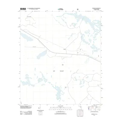
2012 Map of Sargent
USGS Topo · Published 2012About this map
Sargent sits at the center of this 2012 survey, marking a small pocket of settlement within a landscape defined by an intricate network of wetlands and named high ground. The terrain is characterized by numerous islands rising from the surrounding environment, including the descriptively named Devils Cup and Saucer Island, Ox Pen Island, and Long Island. These landforms, along with Yonn Island to the south, suggest a history of seasonal grazing or land use dictated by the fluctuating water levels of the region.
Find a feature on this map
9 named features on this map. Tap any name to fly to it.
Don’t see what you’re looking for? This feature index may not catch every label — zoom into the map to look around manually.
Map Details
Editions of this 2012 Sargent Map
This is the sole edition of this map. No revisions or reprints were ever made.
Other maps of this area

1954 · Valdosta
USGS Topo · 1:250,000

1955 · Council
USGS Topo · 1:24,000

1956 · Eddy
USGS Topo · 1:24,000

1956 · Sargent
USGS Topo · 1:24,000

1958 · Valdosta
USGS Topo · 1:250,000

1959 · Valdosta
USGS Topo · 1:250,000

1965 · Blackjack Island
USGS Topo · 1:24,000

1967 · Strange Island
USGS Topo · 1:24,000

1967 · Sargent
USGS Topo · 1:24,000
1967 · Eddy
USGS Topo · 1:24,000