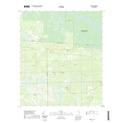
2021 Map of Sargent
USGS Topo · Published 2021About this map
The Okefenokee National Wildlife Refuge dominates this landscape, where the boundary lines of Georgia and Florida intersect amidst a vast network of wetlands and islands. The settlement of Sargent sits as a primary point of reference in a region characterized by the intricate hydrology of the Okefenokee Swamp and White Arm Swamp. The terrain is defined by low-lying rises or "islands" such as Long Island, Ox Pen Island, and the curiously named Devils Cup and Saucer Island, which provide dry ground among the saturated prairies and bays. This map illustrates the transition from managed forest lands and rural access roads like Main Pasture Rd and Watson Line Rd into the protected wilderness. Researchers can trace the specific county divisions of Clinch, Ware, Columbia, and Baker, which converge in this remote corner of the Southeast.
Find a feature on this map
25 named features on this map. Tap any name to fly to it.
Don’t see what you’re looking for? This feature index may not catch every label — zoom into the map to look around manually.
Map Details
Editions of this 2021 Sargent Map
This is the sole edition of this map. No revisions or reprints were ever made.
Other maps of this area

1954 · Valdosta
USGS Topo · 1:250,000

1955 · Council
USGS Topo · 1:24,000

1956 · Eddy
USGS Topo · 1:24,000

1956 · Sargent
USGS Topo · 1:24,000

1958 · Valdosta
USGS Topo · 1:250,000

1959 · Valdosta
USGS Topo · 1:250,000

1965 · Blackjack Island
USGS Topo · 1:24,000

1967 · Strange Island
USGS Topo · 1:24,000

1967 · Sargent
USGS Topo · 1:24,000
1967 · Eddy
USGS Topo · 1:24,000