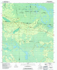
1994 Map of Sargent
USGS Topo · Published 1994About this map
The Georgia Florida state line bisects this survey, revealing a landscape dominated by the expansive wetlands of the Okefenokee National Wildlife Refuge. Small settlements like Sargent, Moorehead, and Traveler are situated along the boundary where the wet prairie transitions into more navigable terrain. The intricate hydrology is defined by features such as Pinhook Swamp and Double Run Swamp, separated by slightly elevated ground where roads like Watson Line Road provide passage. Local topographic curiosities such as Devils Cup and Saucer Island and Ox Pen Island emerge from the standing water of the swamp, illustrating the subtle variations in elevation that dictated human movement and settlement patterns. Further north, the Okefenokee National Wilderness marks a strictly protected environment where Turkey Nest Head and White Arm Swamp represent the untouched character of the Florida-Georgia borderlands.
Find a feature on this map
29 named features on this map. Tap any name to fly to it.
Don’t see what you’re looking for? This feature index may not catch every label — zoom into the map to look around manually.
Map Details
Editions of this 1994 Sargent Map
This is the sole edition of this map. No revisions or reprints were ever made.
Other maps of this area

1954 · Valdosta
USGS Topo · 1:250,000

1955 · Council
USGS Topo · 1:24,000

1956 · Eddy
USGS Topo · 1:24,000

1956 · Sargent
USGS Topo · 1:24,000

1958 · Valdosta
USGS Topo · 1:250,000

1959 · Valdosta
USGS Topo · 1:250,000

1965 · Blackjack Island
USGS Topo · 1:24,000

1967 · Strange Island
USGS Topo · 1:24,000

1967 · Sargent
USGS Topo · 1:24,000
1967 · Eddy
USGS Topo · 1:24,000