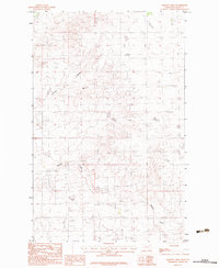
1983 Map of Sargent Creek
USGS Topo · Published 1983About this map
Sargent Creek meanders through this portion of Valley County, Montana, carving a complex drainage network across the Fort Peck Indian Reservation. The landscape is defined by its agricultural and natural water features, including the prominent Johnson Coulee and Porcupine Cr. This 1983 provisional edition, based on field work from the late 1970s, documents the sparse but vital infrastructure of the era, such as various Grainaries and a localized Gravel Pit near the creek's southern reaches. A notable point of interest for local researchers is the label for Anybakken, which stands out as a unique namesake in this otherwise open terrain of the northern plains.
Find a feature on this map
7 named features on this map. Tap any name to fly to it.
Don’t see what you’re looking for? This feature index may not catch every label — zoom into the map to look around manually.
Map Details
Editions of this 1983 Sargent Creek Map
This is the sole edition of this map. No revisions or reprints were ever made.
Other maps of this area

1914 · Nashua
USGS Topo · 1:62,500

1915 · Frazer
USGS Topo · 1:62,500

1915 · Spring Creek
USGS Topo · 1:62,500

1916 · Nashua
USGS Topo · 1:62,500

1918 · Porcupine Valley
USGS Topo · 1:62,500

1954 · Glasgow
USGS Topo · 1:250,000

1957 · Glasgow
USGS Topo · 1:250,000

1958 · Glasgow
USGS Topo · 1:250,000
1972 · Milk River Coulee
USGS Topo · 1:24,000
1972 · Lindeke Coulee
USGS Topo · 1:24,000