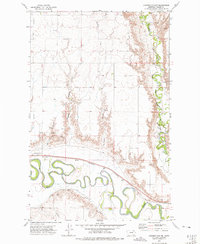
1972 Map of Lindeke Coulee
USGS Topo · Published 1975About this map
The Milk River dominates this Valley County landscape, winding in tight, complex oxbows across the southern reach of the quadrangle. This 1970s survey captures the intersection of natural watercourses and the irrigation infrastructure of the period, including the South Canal and an extensive Aqueduct system. The terrain is defined by dramatic erosion patterns, most notably the deep incisions of Lindeke Coulee and Espeil Coulee, which drain the northern plateau toward the river valley. The Fort Peck Indian Reservation Boundary runs through the eastern portion of the map, while the Burlington Northern railroad tracks parallel the river's northern bank. Local landmarks include Memorial Gardens (Cem) and several scattered Gravel Pits, indicating the small-scale extractive industries supporting the area's development.
Find a feature on this map
17 named features on this map. Tap any name to fly to it.
Don’t see what you’re looking for? This feature index may not catch every label — zoom into the map to look around manually.
Map Details
Editions of this 1972 Lindeke Coulee Map
This is the sole edition of this map. No revisions or reprints were ever made.
Other maps of this area

1914 · Nashua
USGS Topo · 1:62,500

1916 · Nashua
USGS Topo · 1:62,500

1918 · Porcupine Valley
USGS Topo · 1:62,500

1943 · Glasgow
USGS Topo · 1:125,000

1954 · Glasgow
USGS Topo · 1:250,000

1957 · Glasgow
USGS Topo · 1:250,000

1958 · Glasgow
USGS Topo · 1:250,000

1958 · Wheeler
USGS Topo · 1:24,000

1958 · Whately
USGS Topo · 1:24,000

1969 · Hawk Coulee
USGS Topo · 1:24,000