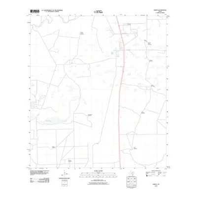
2010 Map of Sarita
USGS Topo · Published 2010About this map
Sarita serves as the focal point of this South Texas coastal plain survey, situated along the corridor of Highway 77. The landscape is defined by its ranching heritage, characterized by an extensive network of named windmills such as the Rancho Verde Windmill, Casa Blanca Windmill, and Turcotte Windmill that dot the arid terrain. To the north and west, the hydrology is marked by the winding course of Los Olmos Creek and the seasonally variable waters of Cayo Lake and Palo Blanco Creek. For those researching local family history, the Sarita Cemetery is a prominent landmark located just north of the town center, while local thoroughfares like Armstrong Ave and La Parra Ave provide a framework for the residential core of the community. This map illustrates the vital role of water infrastructure in maintaining the vast tracts of land surrounding this Kenedy County settlement.
Find a feature on this map
18 named features on this map. Tap any name to fly to it.
Don’t see what you’re looking for? This feature index may not catch every label — zoom into the map to look around manually.
Map Details
Editions of this 2010 Sarita Map
This is the sole edition of this map. No revisions or reprints were ever made.
Other maps of this area

1928 · Sarita
USGS Topo · 1:125,000

1950 · Corpus Christi
USGS Topo · 1:250,000

1952 · Riviera Beach
USGS Topo · 1:24,000

1952 · La Parra Ranch
USGS Topo · 1:24,000

1952 · Riviera Beach
USGS Topo · 1:62,500

1954 · La Parra Ranch SW
USGS Topo · 1:24,000

1954 · Sarita
USGS Topo · 1:62,500

1954 · Riviera
USGS Topo · 1:62,500
1955 · La Parra Ranch
USGS Topo · 1:62,500

1956 · Corpus Christi
USGS Topo · 1:250,000