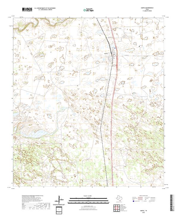
2022 Map of Sarita
USGS Topo · Published 2022About this map
Sarita serves as the small but vital hub of the South Texas brush country, uniquely defined by its role as the seat of one of the nation's least populous counties. The Kenedy County Courthouse stands as the central landmark of the village, surrounded by a sparse grid of local streets including Turcotte St and Mallory St. To the northeast, the Sarita Cem provides a local genealogical record for the area's ranching families. The landscape is characterized by its coastal prairie hydrology, featuring ephemeral drainage systems like Los Olmos Creek along the northern Kleberg Co line and Palo Blanco Creek further south. The presence of Cayo Lake highlights the importance of seasonal water sources in this semi-arid region, where large ranching tracts are bisected by long-stretching roads like La Parra Ave and Armstrong Ave.
Find a feature on this map
13 named features on this map. Tap any name to fly to it.
Don’t see what you’re looking for? This feature index may not catch every label — zoom into the map to look around manually.
Map Details
Editions of this 2022 Sarita Map
This is the sole edition of this map. No revisions or reprints were ever made.
Other maps of this area

1928 · Sarita
USGS Topo · 1:125,000

1950 · Corpus Christi
USGS Topo · 1:250,000

1952 · Riviera Beach
USGS Topo · 1:24,000

1952 · La Parra Ranch
USGS Topo · 1:24,000

1952 · Riviera Beach
USGS Topo · 1:62,500

1954 · La Parra Ranch SW
USGS Topo · 1:24,000

1954 · Sarita
USGS Topo · 1:62,500

1954 · Riviera
USGS Topo · 1:62,500
1955 · La Parra Ranch
USGS Topo · 1:62,500

1956 · Corpus Christi
USGS Topo · 1:250,000