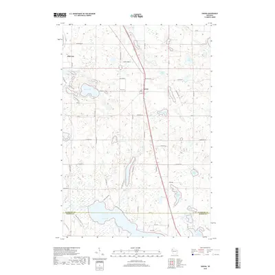
2018 Map of Sarona
USGS Topo · Published 2018About this map
Sarona and the southeastern reaches of Shell Lake anchor this 2018 survey of the glacial lake country along the Washburn and Barron County line. The landscape is defined by its complex hydrology, featuring dozens of named water bodies from the expansive Bear Lake in the south to smaller basins like Little Kekegama Lake and Monday Lake. A prominent transportation corridor is formed by the Wild Rivers State Trail, which cuts a straight path north-south through the center of the quadrangle, passing directly through the community of Sarona and near the Sarona Cem. Local genealogy and land use are reflected in numerous family-named roads such as Heisterkamp Rd, Lapcinski Rd, and Zimmermans Rd, which provide access to the various shorelines and wooded tracts that characterize this portion of northern Wisconsin.
Find a feature on this map
78 named features on this map. Tap any name to fly to it.
Don’t see what you’re looking for? This feature index may not catch every label — zoom into the map to look around manually.
Map Details
Editions of this 2018 Sarona Map
This is the sole edition of this map. No revisions or reprints were ever made.
Other maps of this area

1948 · Spooner
USGS Topo · 1:48,000

1948 · Stone Lake
USGS Topo · 1:48,000

1949 · Spooner
USGS Topo · 1:48,000

1949 · Rice Lake
USGS Topo · 1:48,000

1950 · Stone Lake
USGS Topo · 1:48,000

1951 · Shell Lake
USGS Topo · 1:48,000

1951 · Rice Lake
USGS Topo · 1:48,000

1953 · Rice Lake
USGS Topo · 1:250,000

1959 · Rice Lake
USGS Topo · 1:250,000

1965 · Rice Lake
USGS Topo · 1:62,500