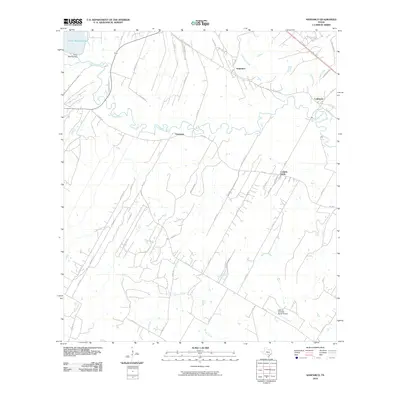
2010 Map of Saspamco
USGS Topo · Published 2010About this map
The San Antonio River meanders across this landscape south of the city, serving as a geographic anchor for the rural communities of Saspamco, Graytown, and Canada Verde. This area, documented in 2010, shows a mix of agricultural expanses and modern infrastructure, including the Victor Braunig Lake and its corresponding Victor Braunig Dam in the northwest. The presence of the John B Connally Ranch Airport reflects the continued integration of private aviation into the ranching traditions of Bexar County.
Find a feature on this map
50 named features on this map. Tap any name to fly to it.
Don’t see what you’re looking for? This feature index may not catch every label — zoom into the map to look around manually.
Map Details
Editions of this 2010 Saspamco Map
This is the sole edition of this map. No revisions or reprints were ever made.
Other maps of this area

1936 · Floresville
USGS Topo · 1:62,500

1953 · Elmendorf
USGS Topo · 1:24,000

1953 · Southton
USGS Topo · 1:24,000

1954 · San Antonio
USGS Topo · 1:250,000

1957 · San Antonio
USGS Topo · 1:250,000

1958 · Losoya
USGS Topo · 1:24,000

1958 · La Vernia SW
USGS Topo · 1:24,000

1958 · Saspamco
USGS Topo · 1:24,000
1961 · Dewees
USGS Topo · 1:24,000
1961 · Floresville
USGS Topo · 1:24,000