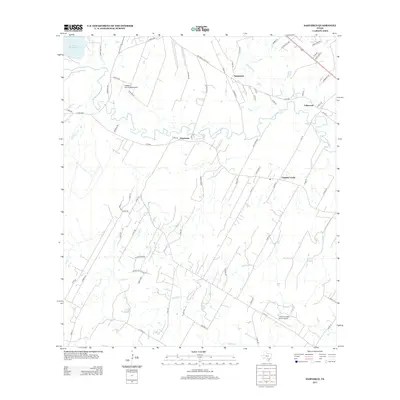
2013 Map of Saspamco
USGS Topo · Published 2013About this map
The San Antonio River snakes across this South Texas landscape, defining the character of the small communities of Saspamco, Graytown, and Calaveras. This region south of San Antonio shows a transition from rural ranchland to industrial and infrastructure sites, evidenced by the presence of Victor Braunig Lake and the John B Connally Ranch Airport. A network of historic paths, including Old Corpus Christi Rd and FM-1303, connect these settlements, which are situated along a complex drainage system featuring Mariana Cr, Calaveras Cr, and Picosa Cr. The map captures the area before modern sprawling development, preserving the layout of private airfields like LSA Landing Airport and the sparse residential pattern of Canada Verde.
Find a feature on this map
72 named features on this map. Tap any name to fly to it.
Don’t see what you’re looking for? This feature index may not catch every label — zoom into the map to look around manually.
Map Details
Editions of this 2013 Saspamco Map
This is the sole edition of this map. No revisions or reprints were ever made.
Other maps of this area

1936 · Floresville
USGS Topo · 1:62,500

1953 · Elmendorf
USGS Topo · 1:24,000

1953 · Southton
USGS Topo · 1:24,000

1954 · San Antonio
USGS Topo · 1:250,000

1957 · San Antonio
USGS Topo · 1:250,000

1958 · Losoya
USGS Topo · 1:24,000

1958 · La Vernia SW
USGS Topo · 1:24,000

1958 · Saspamco
USGS Topo · 1:24,000
1961 · Dewees
USGS Topo · 1:24,000
1961 · Floresville
USGS Topo · 1:24,000