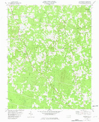
1981 Map of Satterwhite
USGS Topo · Published 1982About this map
Satterwhite and Oak Hill anchor this rural Granville County landscape, where the topography is defined by the drainage networks of Grassy Creek and Bearskin Creek. The map records a community structured around its spiritual and educational hubs, such as St Matthews Ch and the Toler-Oak Hill Sch, reflecting the decentralized settlement patterns common to the North Carolina Piedmont during the late twentieth century. In the northeast corner, the presence of the John H Kerr Reservoir signals the influence of large-scale water management on the local geography. Small family and community crossroads like Wilbourns and Cornwall are interspersed with numerous small burial grounds and churches, including Whetstone Ch and New Corinth Ch, providing vital spatial data for local genealogists and historians tracking family landholdings in the region.
Find a feature on this map
20 named features on this map. Tap any name to fly to it.
Don’t see what you’re looking for? This feature index may not catch every label — zoom into the map to look around manually.
Map Details
Editions of this 1981 Satterwhite Map
This is the sole edition of this map. No revisions or reprints were ever made.
Other maps of this area

1941 · Clarksville
USGS Topo · 1:48,000

1943 · Clarksville
USGS Topo · 1:62,500

1943 · Roxboro
USGS Topo · 1:62,500

1953 · Oxford
USGS Topo · 1:62,500

1953 · South Boston
USGS Topo · 1:62,500

1953 · Greensboro
USGS Topo · 1:250,000

1954 · Greensboro
USGS Topo · 1:250,000

1957 · South Boston
USGS Topo · 1:62,500

1957 · Clarksville
USGS Topo · 1:62,500

1962 · Greensboro
USGS Topo · 1:250,000