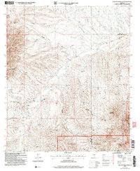
2004 Map of Saucito Mountain
USGS Topo · Published 2006About this map
The Cerro Colorado Mountains and Sheriffs Mesa dominate this southern Arizona landscape, where high-desert drainage systems like Sopori Wash and Batamote Wash define the flow of the terrain. The presence of the Old Sopori Sch and a small Cem suggests a localized community history tied to the area's ranching roots. Working landscapes are evident through the KX Ranch and Santa Lucia Ranch, which sit near the intersection of various desert washes. Along the southern edge, the map transitions into the Coronado National Forest and the Tumacacori Mountains, punctuated by several unnamed Prospect and Prospects sites. This 2004 revision by the Forest Service provides a detailed look at the rural boundary between Pima and Santa Cruz counties along Arivaca Road.
Find a feature on this map
23 named features on this map. Tap any name to fly to it.
Don’t see what you’re looking for? This feature index may not catch every label — zoom into the map to look around manually.
Map Details
Editions of this 2004 Saucito Mountain Map
This is the sole edition of this map. No revisions or reprints were ever made.
Other maps of this area

1920 · Arivaca
USGS Topo · 1:125,000

1925 · Samaniego Peak
USGS Topo · 1:62,500

1939 · Twin Buttes
USGS Topo · 1:62,500

1939 · Tubac
USGS Topo · 1:62,500

1940 · Palo Alto Ranch
USGS Topo · 1:62,500

1941 · Twin Buttes
USGS Topo · 1:62,500

1941 · Arivaca
USGS Topo · 1:62,500

1943 · Arivaca
USGS Topo · 1:62,500

1943 · Palo Alto Ranch
USGS Topo · 1:62,500

1943 · Tubac
USGS Topo · 1:62,500