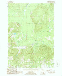
1986 Map of Saunders Creek
USGS Topo · Published 1986About this map
Mackinaw State Forest dominates this northern Michigan landscape, where the headwaters of several key river systems converge. This mid-1980s topographical survey captures the densely wooded transition between the townships of Corwith, Dover, Charlton, and Chester. The drainage patterns are defined by the winding paths of the Pigeon River and Black River, alongside smaller tributaries like Saunders Creek and Tubbs Creek.
Find a feature on this map
12 named features on this map. Tap any name to fly to it.
Don’t see what you’re looking for? This feature index may not catch every label — zoom into the map to look around manually.
Map Details
Editions of this 1986 Saunders Creek Map
This is the sole edition of this map. No revisions or reprints were ever made.
Other maps of this area

1949 · Lewiston
USGS Topo · 1:62,500

1949 · Otsego Lake
USGS Topo · 1:62,500

1950 · Lewiston
USGS Topo · 1:24,000

1950 · Johannesburg
USGS Topo · 1:24,000

1950 · Turtle Lake
USGS Topo · 1:24,000

1951 · Turtle Lake
USGS Topo · 1:24,000

1951 · Johannesburg
USGS Topo · 1:24,000

1951 · Lewiston
USGS Topo · 1:24,000

1954 · Gaylord
USGS Topo · 1:62,500

1954 · Hetherton
USGS Topo · 1:62,500