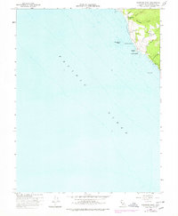
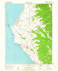
1960 Map of Saunders Reef
USGS Topo · Published 1978About this map
Saunders Reef sits just off a stretch of the Mendocino coast where the land is carved by deep, parallel gulches running to the Pacific Ocean. This survey, based on 1960 field checks with 1976 revisions, shows a landscape defined by its maritime access points at Saunders Landing and Iversen Landing. The inland area is crossed by Iversen Road, connecting the settlement of Craig and the Galloway Sch to the coastal bluffs. Dramatic natural features like Iversen Point and Sail Rock anchor the shoreline, while the drainage patterns of Schooner Gulch and Walker Gulch suggest the difficult terrain that historically shaped local transport and industry. The presence of Saunders Hill and several unnamed structures along the ridges points to the scattered rural residency of this era.
Find a feature on this map
18 named features on this map. Tap any name to fly to it.
Don’t see what you’re looking for? This feature index may not catch every label — zoom into the map to look around manually.
Map Details
Editions of this 1960 Saunders Reef Map
3 editions found
Other maps of this area

1943 · Point Arena
USGS Topo · 1:62,500

1947 · Santa Rosa
USGS Topo · 1:250,000

1949 · Santa Rosa
USGS Topo · 1:250,000

1958 · Santa Rosa
USGS Topo · 1:250,000

1960 · Saunders Reef
USGS Topo · 1:24,000
1960 · Gualala
USGS Topo · 1:24,000
1960 · Point Arena
USGS Topo · 1:62,500
1960 · Point Arena
USGS Topo · 1:24,000
1962 · Santa Rosa
USGS Topo · 1:250,000
1964 · Santa Rosa
USGS Topo · 1:250,000