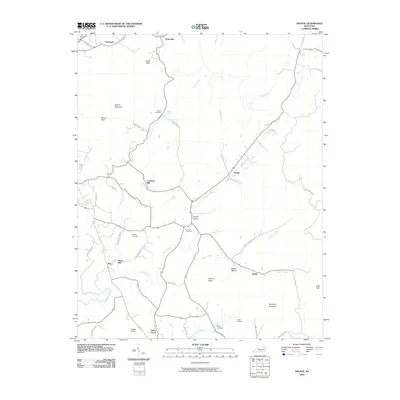
2010 Map of Savage
USGS Topo · Published 2010About this map
Savage and its surrounding hollows characterize this corner of Clinton County, where agricultural life follows the winding paths of Smith Creek and Koger Creek. The terrain is defined by prominent elevations such as Sewell Mountain, Jacks Knob, and Kennedy Mountain, which separate the various valley settlements. Historically significant sites like Cannons Mill and Jones Mill point to a local economy once tied closely to the waterpower of these creeks. Family history is well-preserved across the landscape through numerous burial grounds, including the Gwinn Cemetery, Irvin Cemetery, and Looper Cemetery. The road network, including Old Kentucky Rd and Old Savage Hill Rd, suggests long-established travel routes connecting small communities like Upchurch, Duvall Valley, and Rolan before the modernization of the local infrastructure.
Find a feature on this map
50 named features on this map. Tap any name to fly to it.
Don’t see what you’re looking for? This feature index may not catch every label — zoom into the map to look around manually.
Map Details
Editions of this 2010 Savage Map
This is the sole edition of this map. No revisions or reprints were ever made.
Other maps of this area

1911 · Monticello
USGS Topo · 1:62,500

1914 · Monticello
USGS Topo · 1:62,500

1929 · Byrdstown
USGS Topo · 1:62,500

1934 · Pall Mall
USGS Topo · 1:62,500

1953 · Parnell
USGS Topo · 1:24,000

1953 · Wolf Creek Dam
USGS Topo · 1:24,000

1954 · Cumberland City
USGS Topo · 1:24,000

1954 · Albany
USGS Topo · 1:24,000

1954 · Savage
USGS Topo · 1:24,000

1954 · Powersburg
USGS Topo · 1:24,000