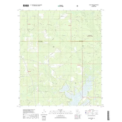
2018 Map of Savage Creek
USGS Topo · Published 2018About this map
Lake Iatt and its surrounding wetlands dominate the southern landscape of this Grant Parish region, where the complex hydrology of Parasol Bayou, Dartigo Cr, and Blue Lick Cr converges. This 2018 survey captures a terrain defined by deep-seated Louisiana watercourses and the pine-covered reaches of the Kisatchie National Forest. The map traces a network of rural roads such as Iatt Rd and French Cemetary Rd that navigate the ridges and bayous, reflecting the region's enduring rural character.
Find a feature on this map
67 named features on this map. Tap any name to fly to it.
Don’t see what you’re looking for? This feature index may not catch every label — zoom into the map to look around manually.
Map Details
Editions of this 2018 Savage Creek Map
This is the sole edition of this map. No revisions or reprints were ever made.
Other maps of this area

1932 · Colfax NE
USGS Topo · 1:31,680

1932 · Colfax SW
USGS Topo · 1:31,680

1932 · Colfax SE
USGS Topo · 1:31,680

1932 · Colfax NW
USGS Topo · 1:31,680

1935 · Verda
USGS Topo · 1:31,680

1936 · Colfax
USGS Topo · 1:62,500

1937 · Aloha
USGS Topo · 1:31,680

1937 · Montgomery
USGS Topo · 1:62,500

1942 · Montgomery
USGS Topo · 1:62,500

1945 · Montgomery
USGS Topo · 1:62,500