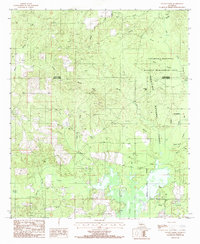
1985 Map of Savage Creek
USGS Topo · Published 1985About this map
Iatt Lake dominates the southern portion of this landscape, its waters reaching into the surrounding piney woods near the boundary of the Winn Parish and Grant Parish line. In the mid-1980s, this area remained largely defined by its natural hydrology and protected lands, with the Catahoula National Wildlife Management Area and Kisatchie National Forest covering much of the eastern terrain. The small settlement of Hurley is situated centrally, connected by a network of unimproved roads and trails that navigate the many waterways, including Latt Creek and Savage Creek. Notable landforms like Potato Hill and Mossy Ridge rise above a dense system of bayous and creeks, such as Bayou Wild Prong and Bayou Bourbe, indicating a territory shaped by seasonal flooding and timber management. A Boat Ramp on the northern shore of the lake highlights the local reliance on the water for both transport and recreation.
Find a feature on this map
28 named features on this map. Tap any name to fly to it.
Don’t see what you’re looking for? This feature index may not catch every label — zoom into the map to look around manually.
Map Details
Editions of this 1985 Savage Creek Map
This is the sole edition of this map. No revisions or reprints were ever made.
Other maps of this area

1932 · Colfax NE
USGS Topo · 1:31,680

1932 · Colfax SW
USGS Topo · 1:31,680

1932 · Colfax SE
USGS Topo · 1:31,680

1932 · Colfax NW
USGS Topo · 1:31,680

1935 · Verda
USGS Topo · 1:31,680

1936 · Colfax
USGS Topo · 1:62,500

1937 · Aloha
USGS Topo · 1:31,680

1937 · Montgomery
USGS Topo · 1:62,500

1942 · Montgomery
USGS Topo · 1:62,500

1945 · Montgomery
USGS Topo · 1:62,500