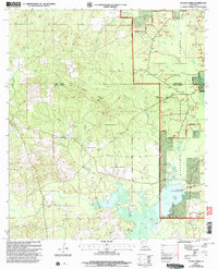
2003 Map of Savage Creek
USGS Topo · Published 2005About this map
Lake Iatt and the expansive wetlands of the Kisatchie National Forest dominate this landscape on the border of Winn and Grant Parishes. The 2003 revision reveals a region defined by complex drainage systems, where Bayou Latt and Bayou Bourbe wind through the timberlands. Much of the eastern portion is dedicated to the Catahoula Wildlife Management Preserve, featuring a network of forest roads and specific points of interest like the Latt Lake Wildlife Viewing Area.
Find a feature on this map
29 named features on this map. Tap any name to fly to it.
Don’t see what you’re looking for? This feature index may not catch every label — zoom into the map to look around manually.
Map Details
Editions of this 2003 Savage Creek Map
This is the sole edition of this map. No revisions or reprints were ever made.
Other maps of this area

1932 · Colfax NE
USGS Topo · 1:31,680

1932 · Colfax SW
USGS Topo · 1:31,680

1932 · Colfax SE
USGS Topo · 1:31,680

1932 · Colfax NW
USGS Topo · 1:31,680

1935 · Verda
USGS Topo · 1:31,680

1936 · Colfax
USGS Topo · 1:62,500

1937 · Aloha
USGS Topo · 1:31,680

1937 · Montgomery
USGS Topo · 1:62,500

1942 · Montgomery
USGS Topo · 1:62,500

1945 · Montgomery
USGS Topo · 1:62,500